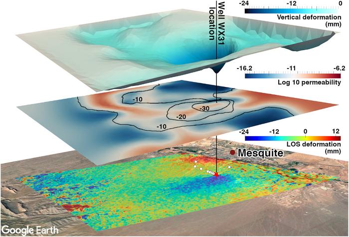
Researchers are using statistics and satellite observations to investigate how groundwater moves through underground aquifers, reducing the need to rely entirely on costly drilling and ground-based monitoring.
A research team from The University of Texas at Austin combined satellite measurements of subtle changes in Earth's surface with a Bayesian statistical inversion framework to estimate how permeability varies within an aquifer.
Permeability determines how easily water can pass through underground rock and sediment.
By examining ground deformation associated with groundwater pumping, the researchers reconstructed a three-dimensional representation of permeability across a municipal aquifer in Nevada.
Their analysis identified a high-permeability channel in the southern part of the aquifer, along with a low-permeability region that earlier studies had suggested might correspond to a geological fault.
The team also found that high-resolution observations from Interferometric Synthetic Aperture Radar (InSAR) provided more detailed information about spatial variations in permeability than multiple GPS measurements used in earlier research.
Published in Geophysical Research Letters, the findings suggest that satellite observations, combined with statistical modelling, could offer water managers a relatively inexpensive way to investigate underground flow patterns and improve aquifer management.
𝐖𝐡𝐲 𝐆𝐫𝐨𝐮𝐧𝐝𝐰𝐚𝐭𝐞𝐫 𝐌𝐚𝐩𝐩𝐢𝐧𝐠 𝐌𝐚𝐭𝐭𝐞𝐫𝐬
Groundwater is a major source of freshwater worldwide. Millions of people depend on aquifers for drinking water, while agriculture relies heavily on groundwater for irrigation, particularly in regions with limited or unpredictable rainfall.
However, groundwater extraction exceeds natural replenishment in many areas. Prolonged overpumping lowers water levels and, under certain conditions, can alter the physical structure of an aquifer.
These changes may have lasting consequences for the amount of water an aquifer can store.
𝐀𝐧 𝐀𝐪𝐮𝐢𝐟𝐞𝐫 𝐂𝐚𝐧 𝐁𝐞 𝐏𝐞𝐫𝐦𝐚𝐧𝐞𝐧𝐭𝐥𝐲 𝐃𝐚𝐦𝐚𝐠𝐞𝐝
An aquifer is not simply an underground lake. Groundwater generally occupies interconnected pores and fractures within rock and sediment.
When water is extracted, pressure within these spaces decreases. The surrounding material may respond by compacting.
If compaction becomes severe and irreversible, some of the pore space that previously stored water can collapse. Consequently, even when rainfall or artificial recharge introduces additional water, the aquifer may no longer have its original storage capacity.
Understanding how underground materials respond to pumping is therefore important for preventing long-term damage.
𝐓𝐡𝐞 𝐂𝐡𝐚𝐥𝐥𝐞𝐧𝐠𝐞 𝐨𝐟 𝐒𝐭𝐮𝐝𝐲𝐢𝐧𝐠 𝐔𝐧𝐝𝐞𝐫𝐠𝐫𝐨𝐮𝐧𝐝 𝐒𝐲𝐬𝐭𝐞𝐦𝐬
Many of the processes governing groundwater movement occur beneath Earth's surface, where they cannot be observed directly.
Researchers cannot easily determine how water is distributed throughout an aquifer or measure how rapidly it moves between underground regions.
Traditionally, groundwater investigations have relied on monitoring wells, pumping tests and geophysical surveys. Although these methods provide valuable information, their measurements are generally limited to specific locations.
This creates a challenge when studying aquifers that extend across hundreds or thousands of square kilometres.
𝐏𝐞𝐫𝐦𝐞𝐚𝐛𝐢𝐥𝐢𝐭𝐲: 𝐀 𝐊𝐞𝐲 𝐭𝐨 𝐔𝐧𝐝𝐞𝐫𝐬𝐭𝐚𝐧𝐝𝐢𝐧𝐠 𝐆𝐫𝐨𝐮𝐧𝐝𝐰𝐚𝐭𝐞𝐫 𝐅𝐥𝐨𝐰
One of the most important properties of an aquifer is permeability, which describes how readily a fluid can move through a porous material.
Highly permeable formations allow groundwater to move relatively easily, whereas low-permeability materials restrict its movement.
Identifying these differences helps scientists understand how groundwater travels through an aquifer and how pumping at one location might affect conditions elsewhere.
Permeability maps can also reveal preferential pathways through which water moves underground.
𝐖𝐡𝐲 𝐏𝐞𝐫𝐦𝐞𝐚𝐛𝐢𝐥𝐢𝐭𝐲 𝐕𝐚𝐫𝐢𝐞𝐬 𝐀𝐜𝐫𝐨𝐬𝐬 𝐀𝐪𝐮𝐢𝐟𝐞𝐫𝐬
Aquifers are rarely uniform.
Some regions contain coarse sediments that permit relatively rapid groundwater movement, while others consist of fine-grained materials that restrict flow.
Fractures may create preferential flow pathways. Geological faults can either facilitate groundwater movement or act as barriers, depending on their structure and composition.
Using a single average permeability value may therefore conceal important differences within an aquifer.
The researchers sought to estimate these variations across the Nevada study area rather than describe the aquifer using one representative value.
𝐇𝐨𝐰 𝐆𝐫𝐨𝐮𝐧𝐝𝐰𝐚𝐭𝐞𝐫 𝐏𝐮𝐦𝐩𝐢𝐧𝐠 𝐀𝐟𝐟𝐞𝐜𝐭𝐬 𝐭𝐡𝐞 𝐋𝐚𝐧𝐝 𝐒𝐮𝐫𝐟𝐚𝐜𝐞
Groundwater pumping changes pressure within an aquifer. These pressure changes can cause the surrounding geological materials to deform, producing small movements at the land surface.
In some cases, the ground may subside by only a few millimetres or centimetres over several months.
Such movements are difficult to detect through ordinary visual observation, but satellite instruments can measure them.
The researchers used these subtle changes as evidence of processes occurring underground.
𝐔𝐬𝐢𝐧𝐠 𝐒𝐮𝐫𝐟𝐚𝐜𝐞 𝐌𝐨𝐯𝐞𝐦𝐞𝐧𝐭 𝐭𝐨 𝐈𝐧𝐯𝐞𝐬𝐭𝐢𝐠𝐚𝐭𝐞 𝐭𝐡𝐞 𝐒𝐮𝐛𝐬𝐮𝐫𝐟𝐚𝐜𝐞
The study addresses what mathematicians call an inverse problem.
In a conventional forward problem, researchers begin with known physical properties and calculate the observations those properties should produce.
An inverse problem reverses this process. Researchers begin with measured observations and estimate the hidden properties responsible for them.
For groundwater systems, pumping changes underground pressure, which affects the deformation of aquifer materials. That deformation can eventually produce measurable movement at the surface.
By analysing these surface movements, researchers can work backwards to estimate the permeability distribution beneath them.
𝐈𝐧𝐒𝐀𝐑 𝐌𝐚𝐤𝐞𝐬 𝐒𝐦𝐚𝐥𝐥 𝐆𝐫𝐨𝐮𝐧𝐝 𝐌𝐨𝐯𝐞𝐦𝐞𝐧𝐭𝐬 𝐌𝐞𝐚𝐬𝐮𝐫𝐚𝐛𝐥𝐞
The research team used Interferometric Synthetic Aperture Radar (InSAR), a remote-sensing technique that measures changes in Earth's surface using repeated satellite radar observations.
InSAR compares the phase of radar signals collected over the same region at different times. These comparisons allow scientists to detect extremely small changes in the distance between the satellite and the ground.
Under suitable conditions, the technique can measure surface displacement at millimetre-scale precision.
For groundwater investigations, these measurements provide information about how the land responds to changes in underground fluid pressure.
𝐓𝐡𝐞 𝐀𝐝𝐯𝐚𝐧𝐭𝐚𝐠𝐞 𝐨𝐟 𝐒𝐚𝐭𝐞𝐥𝐥𝐢𝐭𝐞 𝐎𝐛𝐬𝐞𝐫𝐯𝐚𝐭𝐢𝐨𝐧𝐬
Monitoring wells and GPS stations provide measurements at the locations where instruments are installed.
InSAR, by contrast, can observe deformation across extensive areas, producing a much denser spatial dataset.
Rather than examining surface movement at a limited number of points, researchers can investigate how deformation varies across much of the land above an aquifer.
This broader coverage is especially useful when the objective is to estimate how permeability changes from one underground location to another.
𝐇𝐨𝐰 𝐒𝐭𝐚𝐭𝐢𝐬𝐭𝐢𝐜𝐬 𝐂𝐨𝐧𝐯𝐞𝐫𝐭𝐬 𝐒𝐮𝐫𝐟𝐚𝐜𝐞 𝐌𝐨𝐯𝐞𝐦𝐞𝐧𝐭 𝐈𝐧𝐭𝐨 𝐏𝐞𝐫𝐦𝐞𝐚𝐛𝐢𝐥𝐢𝐭𝐲 𝐌𝐚𝐩𝐬
Satellite measurements do not directly reveal underground permeability. The observations must be interpreted through mathematical and physical models.
The researchers applied a Bayesian inference framework developed by collaborators at UT Austin's Oden Institute for Computational Engineering and Sciences.
Bayesian inference combines observational evidence with prior information and mathematical models while explicitly accounting for uncertainty.
In this study, the framework was used to identify permeability distributions that were consistent with the surface deformation recorded by satellites.
𝐓𝐡𝐞 𝐑𝐨𝐥𝐞 𝐨𝐟 𝐁𝐚𝐲𝐞𝐬𝐢𝐚𝐧 𝐈𝐧𝐟𝐞𝐫𝐞𝐧𝐜𝐞
Bayesian inference begins with possible explanations of a system and updates their plausibility as new evidence becomes available.
For an aquifer, several different permeability distributions may produce similar patterns of surface deformation.
The researchers used InSAR measurements to narrow the range of plausible underground configurations.
Rather than treating one estimated permeability map as perfectly certain, the framework can describe uncertainty across multiple possible permeability fields.
This is particularly useful when the available observations cannot uniquely determine every subsurface property.
𝐖𝐡𝐲 𝐔𝐧𝐜𝐞𝐫𝐭𝐚𝐢𝐧𝐭𝐲 𝐌𝐚𝐭𝐭𝐞𝐫𝐬
Underground geological properties are difficult to determine precisely.
Satellite observations contain measurement noise, physical models require assumptions, and aquifers often have complicated structures.
A statistical method that explicitly represents uncertainty helps researchers assess how strongly the available data support particular interpretations.
It also makes it possible to identify regions where additional observations may be needed.
For groundwater managers, understanding the uncertainty surrounding a permeability estimate can be as important as the estimate itself.
𝐂𝐨𝐦𝐛𝐢𝐧𝐢𝐧𝐠 𝐒𝐭𝐚𝐭𝐢𝐬𝐭𝐢𝐜𝐬 𝐖𝐢𝐭𝐡 𝐀𝐪𝐮𝐢𝐟𝐞𝐫 𝐏𝐡𝐲𝐬𝐢𝐜𝐬
The Bayesian framework was connected to a physical model describing the relationship between groundwater pressure and deformation.
The researchers used poroelasticity, which examines how fluid-filled porous materials respond mechanically when fluid pressure changes.
As groundwater is removed, pore pressure decreases. The solid framework surrounding the pores may then deform, producing movements that can eventually be detected at Earth's surface.
By incorporating this physical relationship, the researchers could connect satellite observations to the underground processes responsible for them.
𝐅𝐫𝐨𝐦 𝐆𝐫𝐨𝐮𝐧𝐝 𝐃𝐞𝐟𝐨𝐫𝐦𝐚𝐭𝐢𝐨𝐧 𝐭𝐨 𝐏𝐞𝐫𝐦𝐞𝐚𝐛𝐢𝐥𝐢𝐭𝐲
The modelling framework connects a sequence of physical processes.
Groundwater pumping alters pressure within the aquifer. The resulting pressure changes propagate through the underground material, with their movement influenced partly by permeability.
These pressure changes cause deformation in the porous geological framework, which can produce measurable surface displacement.
InSAR records that displacement, while Bayesian inversion uses the observations and physical model to estimate the permeability distribution most consistent with the measured response.
𝐑𝐞𝐜𝐨𝐧𝐬𝐭𝐫𝐮𝐜𝐭𝐢𝐧𝐠 𝐚 𝐓𝐡𝐫𝐞𝐞-𝐃𝐢𝐦𝐞𝐧𝐬𝐢𝐨𝐧𝐚𝐥 𝐀𝐪𝐮𝐢𝐟𝐞𝐫 𝐌𝐨𝐝𝐞𝐥
Using the combined framework, the researchers developed a three-dimensional representation of permeability variations within the Nevada aquifer.
Unlike an approach that assigns one average permeability value to the entire system, the model estimated how permeability differed across underground locations.
This distinction matters because groundwater movement can be strongly influenced by local geological structures that are not captured by an aquifer-wide average.
𝐈𝐝𝐞𝐧𝐭𝐢𝐟𝐲𝐢𝐧𝐠 𝐚 𝐇𝐢𝐠𝐡-𝐏𝐞𝐫𝐦𝐞𝐚𝐛𝐢𝐥𝐢𝐭𝐲 𝐂𝐡𝐚𝐧𝐧𝐞𝐥
One of the main findings was a region of relatively high permeability in the southern part of the aquifer.
Such a channel may allow groundwater and associated pressure changes to move more readily through that area.
Identifying these pathways can help researchers investigate interactions between pumping wells and understand how different parts of an aquifer respond when extraction rates change.
The result demonstrates why spatial permeability information can be more informative than a single average value.
𝐀 𝐋𝐨𝐰-𝐏𝐞𝐫𝐦𝐞𝐚𝐛𝐢𝐥𝐢𝐭𝐲 𝐑𝐞𝐠𝐢𝐨𝐧 𝐌𝐚𝐲 𝐈𝐧𝐝𝐢𝐜𝐚𝐭𝐞 𝐚 𝐅𝐚𝐮𝐥𝐭
The analysis also identified a region of relatively low permeability.
Earlier investigations had suggested that this location might correspond to a geological fault.
Faults can influence groundwater movement in different ways. Some create fractures that facilitate flow, while others contain materials that restrict water movement.
The correspondence between the inferred low-permeability region and the earlier geological interpretation suggests that the inversion method captured a potentially important subsurface feature.
𝐇𝐨𝐰 𝐭𝐡𝐞 𝐍𝐞𝐰 𝐌𝐨𝐝𝐞𝐥 𝐃𝐢𝐟𝐟𝐞𝐫𝐬 𝐅𝐫𝐨𝐦 𝐄𝐚𝐫𝐥𝐢𝐞𝐫 𝐖𝐨𝐫𝐤
Previous research on the Nevada aquifer had used GPS measurements of ground deformation to estimate an overall value of hydraulic conductivity, a property closely related to permeability.
That approach provided useful information about the aquifer's general hydraulic behaviour.
However, a single representative value cannot describe how underground properties vary across different regions.
The new framework extends this understanding by estimating the spatial distribution of permeability.
𝐖𝐡𝐲 𝐒𝐩𝐚𝐭𝐢𝐚𝐥 𝐕𝐚𝐫𝐢𝐚𝐭𝐢𝐨𝐧 𝐈𝐬 𝐈𝐦𝐩𝐨𝐫𝐭𝐚𝐧𝐭
Two aquifers can have the same average permeability while responding very differently to groundwater pumping.
One may be relatively uniform, allowing water to move at similar rates throughout the formation.
Another may contain a highly permeable channel surrounded by materials that strongly restrict flow.
Although their average permeability values could be similar, their groundwater-flow patterns and responses to pumping may differ considerably.
Spatially resolved maps provide information that average values alone cannot capture.
𝐂𝐨𝐦𝐩𝐚𝐫𝐢𝐧𝐠 𝐈𝐧𝐒𝐀𝐑 𝐚𝐧𝐝 𝐆𝐏𝐒 𝐎𝐛𝐬𝐞𝐫𝐯𝐚𝐭𝐢𝐨𝐧𝐬
The researchers compared permeability estimates derived from three observational datasets:
-
GPS measurements
-
InSAR observations
-
A combination of GPS and InSAR measurements
This comparison allowed the team to examine how the different monitoring approaches influenced the information available for permeability estimation.
𝐖𝐡𝐲 𝐚 𝐒𝐢𝐧𝐠𝐥𝐞 𝐈𝐧𝐒𝐀𝐑 𝐌𝐚𝐩 𝐖𝐚𝐬 𝐒𝐨 𝐈𝐧𝐟𝐨𝐫𝐦𝐚𝐭𝐢𝐯𝐞
At the Nevada study site, the researchers found that one high-resolution InSAR map provided more detailed and accurate permeability information than multiple GPS observations collected over time.
GPS instruments can measure displacement with high precision, but their observations are restricted to individual monitoring locations.
InSAR offers much denser spatial coverage, allowing the model to capture variations in deformation across a broader area.
For this particular application, the spatial detail provided by the satellite observations was especially valuable.
𝐖𝐡𝐲 𝐌𝐨𝐫𝐞 𝐌𝐞𝐚𝐬𝐮𝐫𝐞𝐦𝐞𝐧𝐭𝐬 𝐃𝐨 𝐍𝐨𝐭 𝐀𝐥𝐰𝐚𝐲𝐬 𝐏𝐫𝐨𝐯𝐢𝐝𝐞 𝐌𝐨𝐫𝐞 𝐈𝐧𝐟𝐨𝐫𝐦𝐚𝐭𝐢𝐨𝐧
The usefulness of a dataset depends not only on the number of measurements but also on where those measurements are collected.
Repeated observations at a small number of locations may provide detailed temporal information without adequately describing spatial variation.
InSAR observations cover much larger areas, making it possible to examine differences in surface deformation between locations.
For the Nevada aquifer, this spatial coverage helped constrain the estimated permeability distribution.
𝐀 𝐏𝐨𝐭𝐞𝐧𝐭𝐢𝐚𝐥𝐥𝐲 𝐋𝐨𝐰-𝐂𝐨𝐬𝐭 𝐀𝐩𝐩𝐫𝐨𝐚𝐜𝐡
An important advantage of the method is its ability to use publicly available satellite observations.
Installing monitoring wells, conducting pumping tests and maintaining extensive GPS networks can require substantial financial and technical resources.
Satellite data collected for Earth observation may provide additional groundwater information without the need for comparable ground-based infrastructure.
This could be particularly useful in regions where monitoring budgets are limited.
𝐖𝐡𝐲 𝐆𝐫𝐨𝐮𝐧𝐝-𝐁𝐚𝐬𝐞𝐝 𝐌𝐞𝐚𝐬𝐮𝐫𝐞𝐦𝐞𝐧𝐭𝐬 𝐑𝐞𝐦𝐚𝐢𝐧 𝐄𝐬𝐬𝐞𝐧𝐭𝐢𝐚𝐥
Satellite observations cannot replace every type of groundwater measurement.
Monitoring wells provide direct information about water levels, groundwater chemistry and local geological conditions that remote sensing cannot independently determine.
The proposed method offers a complementary source of information about aquifer behaviour.
Combining satellite observations with ground-based measurements may therefore provide a more complete understanding of groundwater systems.
𝐈𝐦𝐩𝐫𝐨𝐯𝐢𝐧𝐠 𝐆𝐫𝐨𝐮𝐧𝐝𝐰𝐚𝐭𝐞𝐫 𝐌𝐚𝐧𝐚𝐠𝐞𝐦𝐞𝐧𝐭
Groundwater extraction at one location can affect conditions elsewhere in an aquifer.
Pressure changes may propagate through permeable layers, influencing nearby wells and potentially affecting connected streams or springs.
Understanding the permeability structure helps researchers predict these interactions and assess how pumping may influence different parts of the groundwater system.
Such information can support decisions about extraction rates and locations where excessive groundwater withdrawal could cause substantial drawdown.
𝐏𝐞𝐫𝐦𝐞𝐚𝐛𝐢𝐥𝐢𝐭𝐲 𝐀𝐥𝐬𝐨 𝐀𝐟𝐟𝐞𝐜𝐭𝐬 𝐀𝐪𝐮𝐢𝐟𝐞𝐫 𝐑𝐞𝐜𝐡𝐚𝐫𝐠𝐞
Permeability influences both groundwater extraction and replenishment.
Water entering an aquifer through rainfall, rivers or managed recharge projects must move through underground rock and sediment.
Highly permeable pathways may allow recharge water to spread more readily, while low-permeability materials can restrict its movement.
Mapping these features may help researchers evaluate groundwater-recharge strategies and understand which regions are likely to benefit from additional water.
𝐂𝐨𝐧𝐧𝐞𝐜𝐭𝐢𝐧𝐠 𝐏𝐡𝐲𝐬𝐢𝐜𝐚𝐥 𝐊𝐧𝐨𝐰𝐥𝐞𝐝𝐠𝐞 𝐖𝐢𝐭𝐡 𝐎𝐛𝐬𝐞𝐫𝐯𝐚𝐭𝐢𝐨𝐧𝐚𝐥 𝐃𝐚𝐭𝐚
The research combines established physical principles with statistical inference.
Scientists understand the general relationship between groundwater pressure and deformation, but the detailed permeability distribution within an aquifer is often unknown.
Satellite observations provide measurements of surface movement, while Bayesian inversion connects those measurements to the underlying physical processes.
Together, these components allow researchers to estimate subsurface properties that cannot be measured directly across the entire aquifer.
𝐔𝐧𝐝𝐞𝐫𝐬𝐭𝐚𝐧𝐝𝐢𝐧𝐠 𝐭𝐡𝐞 𝐈𝐧𝐯𝐞𝐫𝐬𝐞 𝐏𝐫𝐨𝐛𝐥𝐞𝐦
In a forward problem, researchers begin with known system properties and calculate the observations those properties should produce.
An inverse problem begins with observations and attempts to determine the properties responsible for them.
The groundwater study follows the second approach: measured surface deformation is used to infer underground permeability.
Inverse problems can be difficult because different subsurface configurations may generate similar observations.
Bayesian methods help address this challenge by representing the range of plausible solutions and their associated uncertainty.
𝐆𝐫𝐨𝐮𝐧𝐝 𝐃𝐞𝐟𝐨𝐫𝐦𝐚𝐭𝐢𝐨𝐧 𝐚𝐬 𝐚 𝐒𝐨𝐮𝐫𝐜𝐞 𝐨𝐟 𝐒𝐜𝐢𝐞𝐧𝐭𝐢𝐟𝐢𝐜 𝐈𝐧𝐟𝐨𝐫𝐦𝐚𝐭𝐢𝐨𝐧
Land subsidence is commonly associated with the damaging effects of excessive groundwater extraction.
Severe subsidence can affect buildings, roads and other infrastructure.
However, the study demonstrates that measurable ground deformation can also provide information about aquifer properties.
The spatial pattern of surface movement reflects aspects of underground pressure changes and geological structure.
When interpreted using appropriate physical and statistical models, these measurements become a useful source of subsurface information.
𝐔𝐬𝐢𝐧𝐠 𝐭𝐡𝐞 𝐋𝐚𝐧𝐝 𝐒𝐮𝐫𝐟𝐚𝐜𝐞 𝐚𝐬 𝐚𝐧 𝐈𝐧𝐝𝐢𝐜𝐚𝐭𝐨𝐫
The method uses deformation at Earth's surface to investigate conditions below it.
Instead of relying entirely on instruments installed underground, researchers observe how the land responds to changes in groundwater pressure.
Differences in surface displacement can contain information about variations in permeability beneath the observation area.
This demonstrates how remote sensing can support investigations of physical processes that are otherwise difficult to observe directly.
𝐈𝐝𝐞𝐧𝐭𝐢𝐟𝐲𝐢𝐧𝐠 𝐀𝐫𝐞𝐚𝐬 𝐕𝐮𝐥𝐧𝐞𝐫𝐚𝐛𝐥𝐞 𝐭𝐨 𝐆𝐫𝐨𝐮𝐧𝐝𝐰𝐚𝐭𝐞𝐫 𝐃𝐞𝐩𝐥𝐞𝐭𝐢𝐨𝐧
Some parts of an aquifer may experience greater compaction than others when groundwater pressure declines.
Where deformation becomes irreversible, groundwater-storage capacity can be permanently reduced.
Combining deformation observations with permeability estimates could help researchers identify areas that may be vulnerable to damage.
Such information may support adjustments to pumping strategies before severe compaction occurs.
𝐓𝐡𝐞 𝐏𝐨𝐭𝐞𝐧𝐭𝐢𝐚𝐥 𝐨𝐟 𝐍𝐈𝐒𝐀𝐑 𝐟𝐨𝐫 𝐆𝐫𝐨𝐮𝐧𝐝𝐰𝐚𝐭𝐞𝐫 𝐌𝐨𝐧𝐢𝐭𝐨𝐫𝐢𝐧𝐠
The researchers also highlighted the potential of NISAR, a satellite mission developed jointly by NASA and the Indian Space Research Organization.
NISAR is designed to collect repeated radar observations of Earth's surface, supporting investigations of land deformation, vegetation changes and other environmental processes.
These capabilities make the mission relevant to groundwater monitoring, particularly where pumping produces measurable surface movement.
𝐅𝐫𝐞𝐪𝐮𝐞𝐧𝐭 𝐎𝐛𝐬𝐞𝐫𝐯𝐚𝐭𝐢𝐨𝐧𝐬 𝐂𝐚𝐧 𝐈𝐦𝐩𝐫𝐨𝐯𝐞 𝐀𝐪𝐮𝐢𝐟𝐞𝐫 𝐀𝐧𝐚𝐥𝐲𝐬𝐢𝐬
NISAR has a repeat cycle of approximately 12 days, allowing researchers to obtain observations of the same region at regular intervals.
Repeated measurements can help scientists investigate how surface deformation changes as groundwater pumping varies over time.
Rather than relying on isolated observations, researchers can develop deformation time series.
These additional measurements could improve the information available for estimating underground properties.
𝐖𝐡𝐲 𝐑𝐚𝐝𝐚𝐫 𝐖𝐚𝐯𝐞𝐥𝐞𝐧𝐠𝐭𝐡𝐬 𝐌𝐚𝐭𝐭𝐞𝐫 𝐢𝐧 𝐀𝐠𝐫𝐢𝐜𝐮𝐥𝐭𝐮𝐫𝐚𝐥 𝐑𝐞𝐠𝐢𝐨𝐧𝐬
Vegetation can complicate radar measurements because changes in plant cover affect the consistency of signals collected over time.
NISAR uses radar wavelengths that can improve measurement continuity in vegetated environments.
This is particularly relevant to groundwater investigations because many heavily pumped aquifers are located beneath agricultural land.
Improved radar observations in these areas could extend the usefulness of satellite-based permeability estimation.
𝐆𝐫𝐨𝐮𝐧𝐝𝐰𝐚𝐭𝐞𝐫 𝐌𝐨𝐧𝐢𝐭𝐨𝐫𝐢𝐧𝐠 𝐢𝐧 𝐀𝐠𝐫𝐢𝐜𝐮𝐥𝐭𝐮𝐫𝐚𝐥 𝐁𝐚𝐬𝐢𝐧𝐬
Irrigated agriculture accounts for a substantial share of groundwater use worldwide.
During dry periods, agricultural demand can place considerable pressure on aquifers, while pumping rates may change with rainfall, crop requirements and seasonal conditions.
Frequent satellite observations could help researchers examine how aquifers respond to these variations.
Combined with statistical models, the resulting deformation measurements may provide additional information about groundwater movement.
𝐀𝐩𝐩𝐥𝐲𝐢𝐧𝐠 𝐭𝐡𝐞 𝐌𝐞𝐭𝐡𝐨𝐝 𝐁𝐞𝐲𝐨𝐧𝐝 𝐍𝐞𝐯𝐚𝐝𝐚
The researchers demonstrated their approach using a municipal aquifer in Nevada.
Other aquifers may differ considerably in their geological structures, mechanical properties, pumping patterns and surface conditions.
These differences can influence the quality of satellite observations and the reliability of permeability estimates.
Nevertheless, the underlying framework could potentially be adapted to other groundwater systems where pumping-related deformation can be measured.
𝐖𝐡𝐲 𝐭𝐡𝐞 𝐌𝐞𝐭𝐡𝐨𝐝 𝐌𝐚𝐲 𝐍𝐨𝐭 𝐖𝐨𝐫𝐤 𝐄𝐪𝐮𝐚𝐥𝐥𝐲 𝐖𝐞𝐥𝐥 𝐄𝐯𝐞𝐫𝐲𝐰𝐡𝐞𝐫𝐞
Not all aquifers deform to the same extent when groundwater pressure changes.
Some geological formations produce measurable surface movement, while others respond much less strongly.
The method's effectiveness therefore depends partly on the mechanical characteristics of the underground materials and the quality of the available observations.
In some settings, additional ground-based or geophysical measurements may be necessary.
The approach should consequently be viewed as a complementary framework rather than a universal replacement for established groundwater-monitoring techniques.
𝐔𝐩𝐝𝐚𝐭𝐢𝐧𝐠 𝐏𝐞𝐫𝐦𝐞𝐚𝐛𝐢𝐥𝐢𝐭𝐲 𝐄𝐬𝐭𝐢𝐦𝐚𝐭𝐞𝐬 𝐖𝐢𝐭𝐡 𝐍𝐞𝐰 𝐃𝐚𝐭𝐚
Bayesian inference provides a framework for updating estimates when additional evidence becomes available.
As new satellite observations are collected, researchers can use them to refine existing permeability estimates.
Groundwater measurements and other relevant datasets may also be incorporated where appropriate.
This creates opportunities for repeated assessment of aquifer properties rather than relying exclusively on one-time investigations.
𝐈𝐦𝐩𝐫𝐨𝐯𝐢𝐧𝐠 𝐆𝐫𝐨𝐮𝐧𝐝𝐰𝐚𝐭𝐞𝐫 𝐏𝐫𝐞𝐝𝐢𝐜𝐭𝐢𝐨𝐧𝐬
Groundwater models require estimates of properties such as permeability and hydraulic conductivity.
When these properties are poorly characterised, predictions of groundwater movement and water-level changes may be uncertain.
Spatially detailed permeability estimates derived from deformation measurements could improve the representation of underground flow conditions.
This may help researchers evaluate pumping scenarios and simulate aquifer responses more realistically.
𝐄𝐯𝐚𝐥𝐮𝐚𝐭𝐢𝐧𝐠 𝐃𝐢𝐟𝐟𝐞𝐫𝐞𝐧𝐭 𝐏𝐮𝐦𝐩𝐢𝐧𝐠 𝐒𝐭𝐫𝐚𝐭𝐞𝐠𝐢𝐞𝐬
Improved knowledge of permeability could help groundwater managers investigate several practical questions.
For example, they could examine how reducing pumping in one area might affect groundwater levels, whether increasing extraction elsewhere would produce similar declines, or how quickly an aquifer might recover after pumping is reduced.
They could also evaluate whether managed recharge would benefit the wider aquifer or remain concentrated within particular zones.
More reliable permeability information provides a stronger basis for examining these possibilities quantitatively.
𝐒𝐭𝐚𝐭𝐢𝐬𝐭𝐢𝐜𝐬 𝐚𝐬 𝐚 𝐓𝐨𝐨𝐥 𝐟𝐨𝐫 𝐆𝐫𝐨𝐮𝐧𝐝𝐰𝐚𝐭𝐞𝐫 𝐌𝐚𝐧𝐚𝐠𝐞𝐦𝐞𝐧𝐭
The research illustrates how statistical modelling can be used to investigate physical properties that are difficult to measure directly.
Rather than simply summarising observations, the Bayesian framework helped infer underground permeability from measured surface deformation.
The resulting estimates provide information about possible groundwater-flow pathways and geological structures.
This application demonstrates the value of combining statistical inference with physical modelling in environmental research.
𝐖𝐡𝐲 𝐒𝐚𝐭𝐞𝐥𝐥𝐢𝐭𝐞 𝐃𝐚𝐭𝐚, 𝐏𝐡𝐲𝐬𝐢𝐜𝐬 𝐚𝐧𝐝 𝐒𝐭𝐚𝐭𝐢𝐬𝐭𝐢𝐜𝐬 𝐖𝐨𝐫𝐤 𝐓𝐨𝐠𝐞𝐭𝐡𝐞𝐫
Each component of the study contributed different information.
InSAR supplied detailed measurements of surface deformation.
Poroelasticity described the physical relationship between groundwater pressure and the mechanical response of aquifer materials.
Bayesian inversion connected these observations and physical relationships to estimates of underground permeability while accounting for uncertainty.
The combination made it possible to investigate subsurface properties that none of the components could determine independently.
𝐓𝐨𝐰𝐚𝐫𝐝 𝐚 𝐁𝐞𝐭𝐭𝐞𝐫 𝐔𝐧𝐝𝐞𝐫𝐬𝐭𝐚𝐧𝐝𝐢𝐧𝐠 𝐨𝐟 𝐇𝐢𝐝𝐝𝐞𝐧 𝐆𝐫𝐨𝐮𝐧𝐝𝐰𝐚𝐭𝐞𝐫 𝐒𝐲𝐬𝐭𝐞𝐦𝐬
Groundwater is difficult to observe directly, yet effective management depends on understanding how it moves and responds to extraction.
The University of Texas at Austin study demonstrates that subtle changes in Earth's surface can provide valuable evidence about underground aquifer properties.
By combining InSAR observations, Bayesian statistical inversion and a poroelastic model, the researchers reconstructed spatial variations in permeability within a Nevada groundwater system.
Their findings identified high- and low-permeability regions, provided more detailed information than earlier whole-aquifer estimates, and showed that a single high-resolution InSAR map could offer greater permeability information than multiple GPS observations in this application.
Although the method's performance will depend on local geological conditions and the availability of suitable deformation measurements, it offers a promising addition to existing groundwater-monitoring approaches.
As radar satellite observations become more frequent and detailed, methods of this kind could help researchers and water managers better understand aquifer behaviour, assess groundwater-extraction strategies and identify potential risks before long-term damage occurs.
𝐉𝐨𝐮𝐫𝐧𝐚𝐥 𝐑𝐞𝐟𝐞𝐫𝐞𝐧𝐜𝐞
Amal Alghamdi et al. Study on poroelasticity-based Bayesian inversion of remotely sensed aquifer deformation for permeability characterization. Geophysical Research Letters.