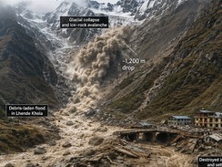
The devastating flash flood that struck northern Nepal near the Tibet border on 26th August 2026 can be understood as a cascading geological and geomorphological disaster, rather than simply a conventional rainfall-induced flood. Preliminary investigations indicate that the event was associated with the collapse of a substantial portion of a Himalayan glacier, followed by an ice–rock avalanche and the rapid movement of water, sediment, and boulders into the Lhende Khola and connected river systems. Satellite observations reportedly showed that a section of the glacier collapsed from high elevation and descended approximately 1,200 m toward the valley floor. The resulting mass movement generated enormous quantities of loose ice, rock and sediment, which entered the drainage system and produced an exceptionally rapid flood wave. A seismic signal initially interpreted as an earthquake was subsequently associated with the glacial collapse itself. This distinction is important from a geological perspective because it demonstrates how mass wasting in high mountain environments can generate earthquake-like ground vibrations while simultaneously initiating catastrophic flooding. The steep Himalayan relief provides ideal conditions for rapid downslope movement, while deeply incised valleys concentrate water and debris into narrow channels. The flood therefore represented a combination of glacial instability, slope failure, debris flow, river-channel confinement and sudden hydrological discharge. Reports indicate that river levels downstream rose dramatically within a short period, allowing little time for communities and infrastructure located along valley floors to respond.
From a geological and geomorphological standpoint, the severity of the disaster was strongly controlled by the physical characteristics of the Himalayan mountain system. Nepal lies within one of the world's most tectonically active regions, where the Indian Plate continues to converge with the Eurasian Plate. This tectonic setting has produced extremely high mountains, steep slopes, fractured rocks and active fault systems. These characteristics make the landscape naturally susceptible to rockfalls, landslides, debris flows and other forms of mass wasting. Glacial processes further modify the terrain by eroding bedrock, transporting sediment and creating unstable moraines and glacial lakes. When glaciers retreat, the resulting oversteepened slopes and poorly consolidated glacial deposits can become increasingly unstable. Glacial lakes may also be retained behind moraine dams that have relatively low resistance to sudden failure. A previous study of the 2024 Thame Valley disaster in Nepal demonstrated how a rock avalanche entering a glacial lake could initiate a cascading glacial lake outburst flood, followed by channel erosion, sediment deposition and continuing slope instability. Although the August 2026 event is currently being described primarily as an ice–rock avalanche and glacial-collapse-induced flash flood, rather than definitively as a conventional glacial lake outburst flood (GLOF), the underlying geological processes are closely related. The enormous sediment load carried by such floods can increase their density and destructive power, transforming ordinary floodwater into a debris-rich flow capable of transporting large boulders and destroying bridges, roads, buildings and hydropower facilities. Thus, the disaster illustrates how geological structure, topography, glacial processes and fluvial systems interact to amplify natural hazards in the Himalayas.
Climate change is an additional factor that must be considered when interpreting the geological significance of the Nepal disaster. Rising temperatures are accelerating glacier retreat and changing the stability of high-altitude ice, snow and permafrost. Glacier thinning can expose unstable slopes and increase the development or expansion of glacial lakes, while thawing frozen ground can reduce the strength that previously helped bind rock and sediment together. These processes can create conditions favourable for rock avalanches, ice avalanches, landslides and sudden flood generation. Research on Himalayan glacier-lake hazards has shown that thousands of glacier lakes are associated with potentially unstable moraine dams and that large outburst floods can produce peak discharges comparable with major monsoonal rivers far downstream. Consequently, geological hazard assessment in Nepal should increasingly adopt a multi-hazard and cascading-hazard approach, rather than treating floods, landslides, avalanches and glacier-related events as independent phenomena. Detailed geological mapping, remote sensing, satellite-based monitoring of glacier movement, digital elevation models, river-channel surveys and real-time hydrological monitoring can help identify vulnerable areas. Particular attention should be given to settlements, roads, bridges and hydropower installations constructed along narrow Himalayan valleys. Early-warning systems should integrate glacier deformation, rainfall, river discharge, landslide activity and seismic signals so that a warning can be issued before a cascading event reaches downstream communities. The Nepal disaster therefore provides an important geological lesson: in a rapidly changing Himalayan environment, catastrophic flooding may begin not with rainfall alone but with the sudden failure of ice, rock, sediment and mountain slopes, creating a chain of processes whose combined impact can be far greater than that of any individual hazard.